Soil-landscape relations
The CSME Group uses landscape models as a helping tool in soil assessment, identification of areas with different agricultural potential and sample design. The most common landscape models used by CSME are geomorphic surfaces, curvature and slope segments. The advantage of using these models is related to their practicality, since the boundaries among different sites with different soils and agricultural potential can be accurately identified in the field by an experienced mapper. Considering that one of the reasons for the lack of knowledge about the variability of soil attributes, in many areas around the world, is due to high costs and time demanding required in order to perform a detailed conventional survey, these models present a large potential. The CSME Group has been working with these models for a great variety of source materials, on different scales, in areas ranging from 1 to 770 ha. There are many applications: label adaptation of detailed soil surveys, identification of accuracy limits of mapped sites, identification of site-specific management for citrus, coffee and sugarcane crops, variable rate of input application, planning and sampling optimization, variable sub soiling depths, identification of areas with different potential for CO2 emissions, loss of soil and nutrients by erosion and others.
Imagens
Temas relacionados
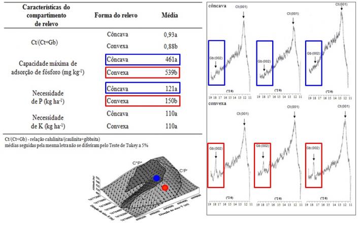
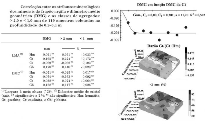
Pedoenvironmental indicators – Soil Mineralogy
The CSME Group has experience on the characterization and mapping of clay minerals (hematite, goethite, kaolinite and gibbsite). Pedoenvironmental indicators are considered important because their attributes, such as crystallinity, specific surface area, isomorphic substitution and contents, show distinct features throughout the landscape. Since those minerals are responsible for most part of the tropical soil characteristics, such as color, nutrient adsorption, aggregate stability, root penetration resistance, erodibility, CO2 emission influence and sorption of heavy metals, their study is of great importance. The results may help on the usage of agricultural inputs with a reduction on the environment impact, development of an index of soil contamination by heavy metals and strategic urban planning regarding the location of dumps and landfills.
Imagens

Temas relacionados
Methods for indirect quantification of soil and plant attributes
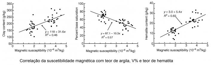
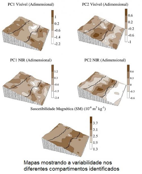
Agricultural, urban and environmental strategies on land use are made based on the detailed characterization of its attributes. For that, it is known that a large number of samples is needed, what raises laboratory test costs and its respective demanded time. Thus, the indirect quantification is becoming a viable alternative to assess a detailed characterization of soil and plant attributes. The Diffuse Reflectance Spectroscopy (DRS) and Magnetic Susceptibility (MS) are two methods of indirect quantification with a great potential for agricultural, urban and environmental applications. These methods can be used, for example, to estimate clay and minerals contents and even liming needs, erosion risks and heavy metal potential adsorption. The advantages of using them is that they can be quickly applied over all types of soil, are easy to use and cause no environmental impact, since they do not require the use of chemical reagents. Another advantage is that the tests can be performed either in the field or at a laboratory, and also be used as a complement of other analysis.
Imagens
Temas relacionados
Mathematical models in agricultural sciences
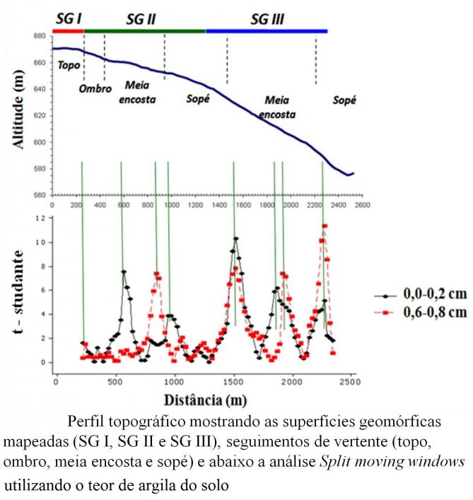
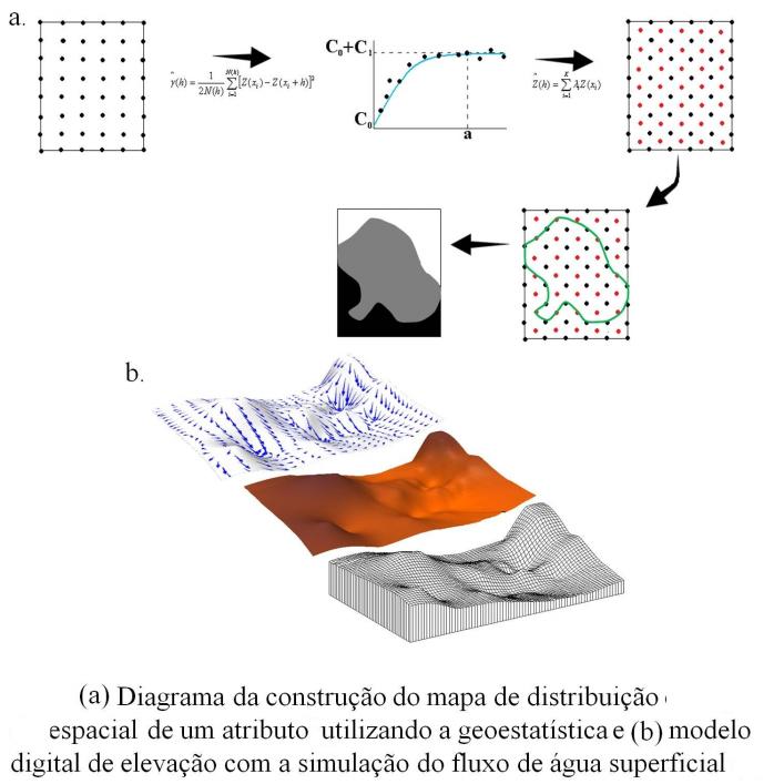
Mathematical modeling originated from the necessity of human beings to understand their environment. In Agricultural Sciences, it helps to answer fundamental questions about the management of sustainable areas. After the consolidation of the tridimensional soil concept (continuous variation of soil along the landscape), the identification of the boundaries among the different existing soil classes in a map became one of the requirements to perform agriculture planning and management. The “Split Moving Windows” technique is a modeling tool that assists on the identification of these limits, decreasing the subjectivity degree and inaccuracy level of conventional maps. Another tool that has been used on the representation of soil attributes over different landscape spots is the Geostatistics. It assists on the variability and mathematical modeling and is also used on the representation of soil-plant interactions. The environmental phenomena are provided, simultaneously, by different factors. Studies regarding the soil-plant relationship must take into account a large number of variables. However, if this relationship is described by the means of univariate statistics, which each variable is studied either separately or in pairs, interpretations and conclusions can be compromised, as the interrelation is not considered. For this reason, the multivariate analysis has been more frequently used in Agricultural Sciences when the interrelationship among soil and plant variables is studied. The CSME Group works with these and also other tools, such as the fractal analysis, Gaussian sequential simulation and decision tree, to represent the agricultural environment, applying the modeling on soil and water management and conservation, detailed mapping of soil properties and gas emissions by agricultural activities.
Imagens
Temas relacionados
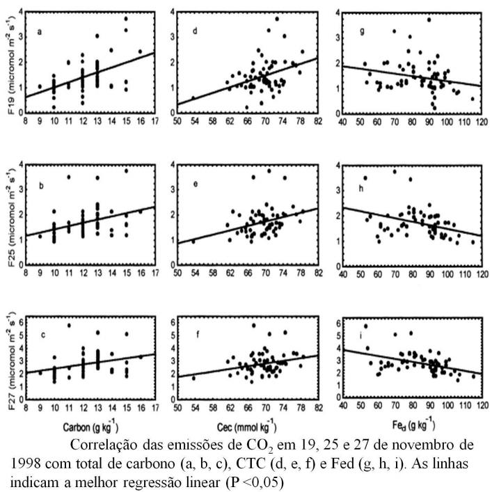
Soil respiration and global warming
The carbon dioxide (CO2) release is a natural phenomenon on Earth. However, this release, due to human activities, especially those related to soil management, has been the subject of numerous studies on global climate change. The Intergovernmental Panel on Climate Change (IPCC) reports have stressed the need for adaptation of many productive sectors. In this context, the CSME Group aims to understand aspects of CO2 emissions from soil using field sensors, mathematical models and landscape models. These results may support the development of Public Policies on this subject, the elaboration of inventories of agricultural emissions, the construction of future scenarios of global climate changes and the development of mitigation strategies.
Imagens
Temas relacionados
Soil and water management and conservation
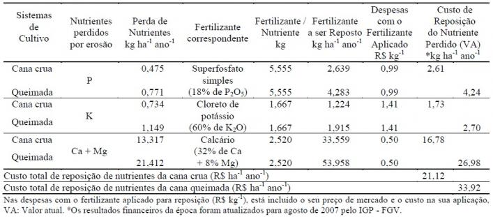
The soil erosion phenomenon is the most significant kind of soil degradation, affecting crop yields and the environmental pollution, which can be divided into: 1) caused by domestic and industrial effluents; and 2) caused by residues and effluents of agricultural areas, such as lime, fertilizers, insecticides, fungicides, herbicides, animal wastes, antibiotics, sediments and microorganisms. In agricultural areas, the soil erosion is considered the main source of pollution. In order to improve the environmental quality of production processes and products, companies need technological innovations that increase their competitive advantage in a sustainable manner. This way, the CSME Group has been working to develop techniques to assist on the accurate and fast modeling of erosion processes. Some practical applications of our research aim to establish a new planning model for the management of agricultural residues from sucro-energetic matrices. It was observed that soil which is at least 50% covered by crop residues shows a significant reduction of water and soil loss. Considering the use of sugarcane straw for bioenergy production, this can lead the companies to establish the optimal amount of straw left over each soil type in order to decrease possible impacts. Other results are related to the production of soil maps regarding erodibility risks, what can allow a scenario construction to assist local planning. This kind of information makes possible the evaluation of erosion-yield relations of each crop.
Imagens
Temas relacionados
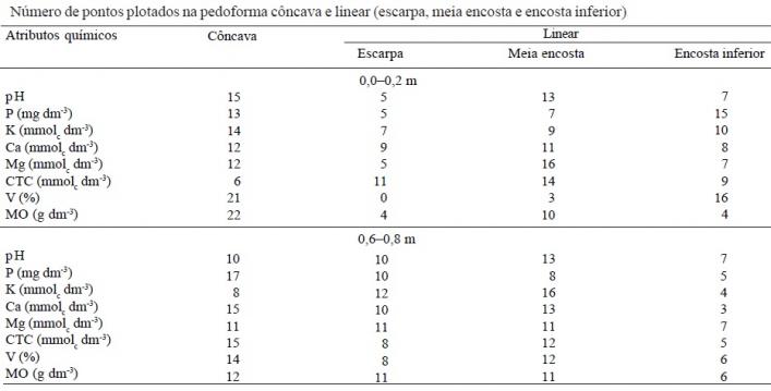
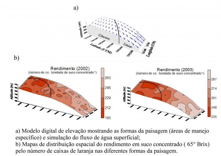
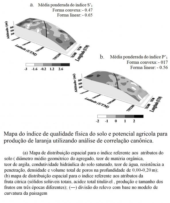
Mapping of site-specific management
Part of the variability of agricultural production is associated, among other factors, with the variability of soil attributes. However, the majority of soil maps, even those in detailed scale (≥ 1:10,000), does not show records of the spatial variability of attributes. This is also observed on the technical mapping for production environments of sugarcane crops, land use and management, environmental impact assessment and any other map that relates to the technical information from a soil map. In order to better understand the spatial variability of the soil attributes and crop yield responses, the CSME Group uses two procedures for the identification and mapping of site-specific management. A hybrid map is generated by the union of these two procedures and is able to increase the knowledge of the soil distribution, their attributes and quality information as it reduces the subjectivity of other methods. The detailed characterization of the soil spatial variability and its attributes can be used for different applications, such as: - to assist on the biodiversity characterization, defining conservation mechanisms, its economic potential and its sustainable use; - to assist on the agricultural and industrial planning of sucro-energetic matrices; - to help the understanding of land use and management over global climate changes, providing information that supports decision making on mitigation and adaptation strategies; - to assist governmental departments on their strategic planning.
Imagens
Temas relacionados